Topological and Geographical Data of Germany50 and CORONET CONUS Networks
Amaro de Sousa1,2, Dorabella Santos2, Paulo Monteiro1,2,
Determination of the Minimum Cost Pair of D-Geodiverse Paths, DRNC 2017
1 DETI, Universidade de Aveiro, Aveiro, Portugal,
2 Instituto de Telecomunicaçőes, Aveiro, Portugal
This page presents the topological and the geographical data of Germany50 and CORONET CONUS networks used in the paper
"Determination of the Minimum Cost Pair of D-Geodiverse Paths", presented in 13th Int. Conf. on Design of Reliable
Communication Networks (DRCN), Munich, Germany, March 8-10, 2017.
- The geographcal location of each node and the end nodes of each link are based on SNDlib
for the Germany50 network and on Sample Optical Network Topology Files for the
CORONET CONUS network.
- Geographical distances and lengths were computed based on the methods described in
http://www.movable-type.co.uk/scripts/latlong.html
which consider a spherical earth and ignore ellipsoidal effects.
- Geographical distances and lengths are in Kms and rounded to integer values.
- We consider that links follow the shortest path over the terrestrial surface between the locations of their
end nodes.
- Longitude and latitude values of node locations are in signed decimal degrees.
- The number of network nodes is represented by N and the number of network links is represented by L.
- Nodes are represented by positive integers between 1 and N.
- Links are represented by positive integers between 1 and L.
Distance definitions:
- The distance between one Node and one Link is the minimum geographical distance between the Node and any pont of the Link.
- The distance between two Links is the minimum geographical distance between any point of one Link and any point of the other Link.
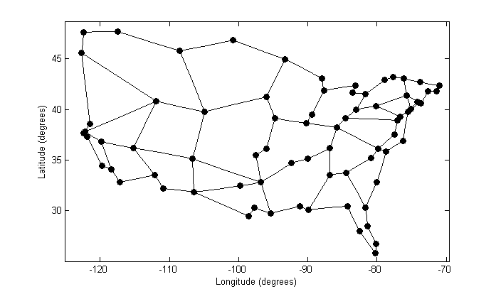
Germany50 (N = 50, L = 88)

CORONET CONUS (N = 75, L = 99)
Instituto de Telecomunicaçőes, 2017 - Contact: Amaro de Sousa (asou@ua.pt, asou@av.it.pt)